EN
EN DE
DE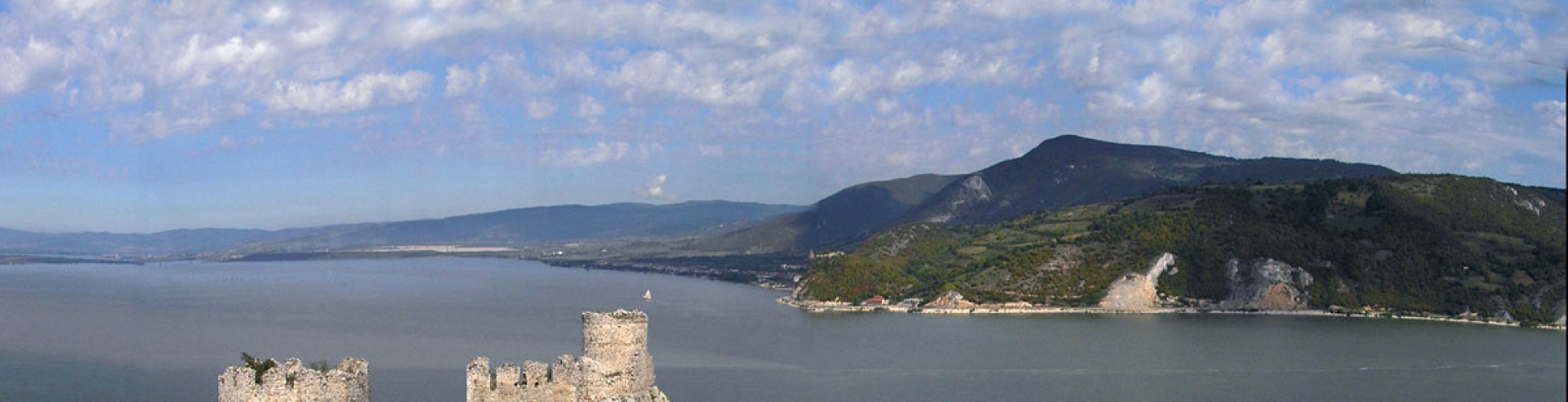
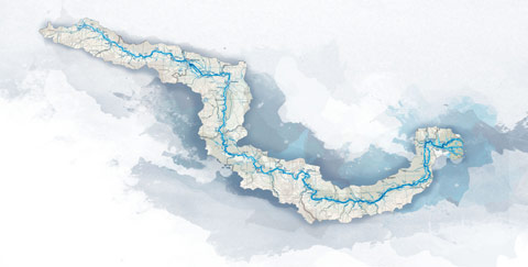
Cycling trail in Serbia, SECTION 6: Stara Palanka - Ram - V. Gradiste - Golubac - D. Milanovac
Section 6:[br/] Stara Palanka (Ban. Palanka) – Ram – Srebrno jezero (Silver Lake) – Veliko Gradiste – Golubac – Donji Milanovac (95km)[br/] Near the ferry dock in Ram is the tavern Lederata (E). Between the river and the tavern you can put up a tent if the sun already began to set (but, ...
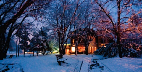
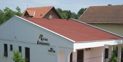
City: Veliko Gradiste
Country: Serbia
Cycling trail in Serbia, SECTION 6: Stara Palanka - Ram - V. Gradiste - Golubac - D. Milanovac
Section 6:
Stara Palanka (Banatska Palanka) – Ram – Srebrno jezero (Silver Lake) – Veliko Gradiste – Golubac – Donji Milanovac (95km)
- Map (2,633Kb)
GPS track logs & waypoints for this base *
Section West (Sections 1- 4: Backi Breg - Apatin - Backa Palanka - Novi Sad - Belgrade)
Section East (Sections 5-7: Belgrade - Pancevo - Ram - Golubac - Đerdap - Kladovo - Negotin - Bregovo)
E – Food
U – Sleeping accommodation
Note: Complete text and GPS marking was done by Ciklonaut Serbia, e-mail: jone@ciklonaut.com
Near the ferry dock in Ram is the tavern Lederata (E). Between the river and the tavern you can put up a tent if the sun already began to set (but, just in case, ask the personal in the tavern for admission).
Ram, ferry dock: 0km
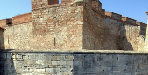
We ride straight ahead, uphill for less than 1km and get from 72m to 118m above sea level. After 300m we turn right into a little road, which leads us to the fortress of Ram.
The city Ram is first mentioned in 1128 – there was a battle near the city, in which the Byzantines won against the Hungarians. The fortress, the vestiges of which remained up to now, was built by the Turkish sultan Bajazit II at the end of the 15th to the beginning of the 16th century. The fortress has five towers connected with high walls. The fortress is shabby and overgrown in grass. But, the view from the walls is amazing. Beware of the snakes in summertime.
Detour No.8: Ram – Zatonje
At the arriving point of the ferry from Stara Palanka, begins a road to the left which leads the village Zatonje along the riverside (9km). It is a gravel road which soon after becomes an earthy one. The view is very nice: at the opposite riverside is the mouth of the river Nera, which is the borderline between Serbia and Romania and on the Rumanian side you can see the first green mountains of the Carpathians – which is a total contrast to the flat landscape on the Serbian side of the border. At the second part we have to drive uphill along Veliko brdo (great hill), where the road is sandy and very hard to ride on, so we will probably have to push our bicycles for a while. On the other hand, the view is really fantastic. This detour is for all those, who have mountain-bikes, who are curious enough and patient as well, since riding on such poor ground is very hard.
1,8km
R94 – right turn leads to Kostolac and Pozarevac; we move on straight ahead. The road to Srebrno jezero is calm; the asphalt to Zatonje is of average quality, and afterwards is in a very good condition.
7,1km
R95 – the village Zatonje. Directly after a huge yellow house on the left side of the road we reach the crossroad where we have to turn left and go downhill. Here is also a pointer, showing us the way to Srebrno jezero – but it turns just with the wind, so it would point us to the right direction if we are lucky or if the wind likes us.
After a short downhill ride along a narrow road we reach a road, which leads along the Danube on the one and the Srebrno jezero (Sliver lake) on the other side. The part of the journey ahead of us is 7km long and very beautiful. We ride on the bank on a small asphalted road with moderate traffic, between two watercourses – a river and a lake. The space ahead of us is enormously wide: view covers a glorious curve of the Danube, we notice a radiant church tower in picturesque Romanian village Divici, or we can look over the lush green waterside of the Silver Lake. The lake will then hide under the veils of the bog land until we reach the end of the lake, where we can once again enjoy riidng on the bank between the two watercourses. The Danube will go with us all the way on our left side.
15,0km
Srebrno jezero (The Silver Lake). The lake was created vy separating two Danube-arms; the eastern one is the tourist epicentre. There are hotels and numerous boarding houses (E, U) (mainly in very good or fantastic quality) and restaurants, a cultivated beach, a boardwalk, a camping ground (U)… There is also the possibility of cruising the Danube in a tourist boat (the owner alludes to us that the drive is free for people over 70 accompanied by their parents).
If we grew tired of our journey, this is a perfect place to have a rest. You can the camping ground and the hotels by going along the board walk next to the lake; the boarding houses and the restaurants are directly in front of us.
15,3km
R96 – we continue our ride by turning left at the crossroad in the centre of the weekend-colony (please pay attention to the pointer “Beli Bagrem” – “White acacia”), from where a calm asphalted road leads us back to the riverside.
15,5km
A right turn leads to the restaurant Beli Bagrem (E).
17,0km
R97 – at the entry to the city Veliko Gradiste begin an asphalt road to the right; but we remain on the road along the Danube riverside by taking a half-left bend..
18,1km
Dock of the ferry to Romania and border passing. The ferry is only for passengers (no cars) and leaves for the Romanian city Moldovi every day at 9am. The return is at 2pm Serbian time (3pm Romanian time). Mind the time changes during the winter.
Directly after the ferry dock there is a park – a common place to have a break. To continue our ride we turn right and after about 100m make another right turn. By doing this we reach the main street of Veliko Gradiste. On both sides are low trees and low buildings, old and a bit unkempt. There is the post office in this street, a bakery and several shops. This little city gives you the pleasure of gradually going down to the Danube Being situated at the mouth of the golden river Pek, time goes by very slowly in Gradiste, so you feel that Belgrade’s timeline is yet to happen here..
18,4km
After about 140m since we turned into the street, on the left side we will notice a passage, which leads through the buildings to a yard behind them. There is a bicycle repair garage, which is simple but can be very useful if we need help. Ask for an older guy called “Slovenac”.
18,7km
The shop “Auto Misa”, where you can buy replacement parts for cars and bikes as well. It’s on the right side of the three street crossroad of. Here we turn half-left, pass a roundabout traffic (it remains on our right side) and turn half-left again to R98.
19,0km
R98 – main road leads straight ahead to Golubac; and to the left is calmer and even more beautiful side road over the village Pozezeno, which also leads to Golubac. We choose the side road and thus make a left turn at this point.
20,5km
We pass a bridge over the river Pek.
20,6km
Rd34 – left turn leads to the river bank road. We move on straight ahead, remaining on the asphalted main road.
20,7km
R99 – straight ahead is a road leads to Branicevo. We turn half-left here.
21,9km
R100 – another crossroad to Branicevo (right); to get to Pozezeno and Golubac we have to turn half-left here.
23,6km
R101 – a crossroad: going straight ahead leads to the centre of Pozezeno. We turn left along the main road.
24,1km
A side road, which also leads to the centre, turns left here.
24,4km
Rd34 – on our left side is an asphalted road, which also leads to Pozezeno and is the end of the detour mentioned above. We move on straight ahead.
30,1km
The village Vinci.
30,4km
The café Holivud (E). It is situated on the riverbank with an amazing view from the terrace, onlooking Romania.
Detour No.9: Along the bank road from Veliko Gradiste to the village Pozezeno (6km)
We can also reach Pozezeno riding on the bank road. In this case we have to turn left at Rd34. There is a short, earthy part of the road, so we recommend this detour only during good weather.
Rd33: 0km
1,95km
Now we are riding on the part of the bank road of poor quality. Thus we can switch to parallel earthy road at this point, which is in a better condition.
4,2km
Entry to Pozezeno.
4,8km
The restaurant Alaske zore (E). Situated in a good position.
5,1km
Rd34 – we part from the riverside at this point and turn right, towards the main road.
5,7km
We enter the main road at Rd35.
31,4km
We ride past a large pine forest, with a huge weekend-colony with more than 1000 houses – you can hardly say that there are so many houses because the greenery dominates. At this point begins a small road to the right, towards 700m remote boarding house Dunavski Raj (Danube paradise) (E, U). This boarding house is situated in a wonderful area in the middle of the forest, the building is large and new and offers a lot for a relatively low price. (The only weak point is the dining room, which seems a little claustrophobic – we recommend sitting outside during good weather.)
32,7km
There is a pointer at this point suggesting that you turn left to get to a pizza parlour, a bakery and a beach. The pizza parlour has a bit odd working hours (5pm – 1am); it is not clear whether the bakery really exists, and the beach is a bit odd too – it is altogether pretty much desolated during the day. But for the people who love camping in ‘forbidden’ areas, there is enclosed field behind the pizza parlour. In front of the pizzeria is a nice spring, there is a toilette in the yard – all inclusive for undemanding passangers. Ask for permission in the pizzeria.
33,2km
R102 – the village Usije, centre. In front of the tavern ambitiously named Casablanca, reminding us of village taverns in the Andes, there is a crossroad in the form of a triangle, where Humphrey Bogart and Ingrid Bergmann may as well have said goodbye to each other. Turning half-left at this point is quite enough for us..
34,9km
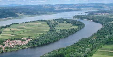
R103 – we reach the main road Gradiste – Golubac. If you ride straight ahead you get to the village Radosevac but at this crossroad we turn left towards Golubac. After one kilometre we can see the broadest section of the Danube (5,7km), which lolls back here before it enters the Djerdap gorge..
37,6km
R104 – crossroad in Golubac. Turn left (and uphill), then you get to the village Malesevo and the convent Tumane; we move on straight ahead.
37,8km
Golubac, centre. If you turn left you come to the hotel Golubac (E, U). Behind the hotel and along the beach is a wonderful large park, where you can see the wideness of the river again and get lost in the sight.
38,6km
At the gateway from Golubac is a cultivated spring on the right side.
42,0km
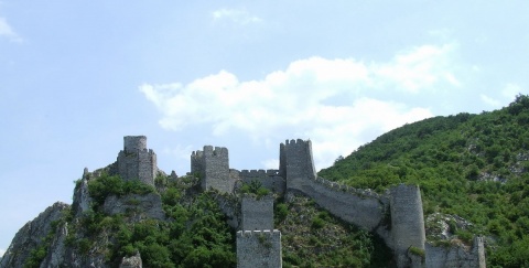
At the entry to the fortress of Golubac (Jerinin grad – City of Jerina) is a cultivated spring right beneath, a memorial-spring to Zavisa Crni. Zavisa was a popular polish knight, who lost his life in the battle against the Turks in 1428.
One hundred metres before the fortress we passed a huge pointer, marking the beginning of the national park Derdap. We exit the park at the ancient colony Dijana some hundred metres before Kladovo. Our way leads along one of the most beautiful parts of the whole Danube. Ancient history and exceptional beauty of nature, with more than 100km of brewing riverside and fantastic great canyons, mystic desolate bays, fields, forests, rocks, high cliffs, huge mountains, little rivers, rivulets and springs, ancient walls, towering from the water, the ghosts from rapt Atlantis – islands, cities and villages – and a dizziness when you stand above the abyss of 7000 year-old timeline.
At this part the asphalt is solid or very good (road is patched only in several places) and the traffic is very moderate, a bicyclist’s paradise. (Dunavska magistrala (the Danube highway), a common name for the road Golubac – Donji Milanovac – Kladovo – Negotin, is far from reality. You could better name this strip of asphalt “calm Danube pathway for good tempered travellers on bicycles”, for it is cooped up between rocks and the water.
Fortress-city of Golubac
Nobody knows who built this fortress-city, which is first mentioned at the beginning of the 14th century as Hungarian fortress. It is believed, however, that Slavs form Branicevo built it. Ever since the battle of Kosovo until the 19th century The Turks and the Serbs fought over the ownership of it (for the Turkish it was one of the most significant border-cities) and finally it got back to Serbia in 1867. The city has 9 towers, which are up to 25m high, and it is divided into the upper and the lower part. Golubac is one of the most important mediaeval cities in the Balkans.
It is nice to rest here and go for a walk round the city, permeated with towers and walls and enjoy the view.
From here you can see the silent fortress, calm and absorbed in itself. If we go on we notice that the fortress looks different when we reach it from Golubac and when we leave the fortress behind on the way to Milanovac. On the Golubac side the sun sets on her stones, and like expensive make-up on the face of an old woman it manages to soften the sharp-edged angles and the rips of the ruins, which melt in the water. At the Milanovac side the fortress looks toothless, encumbered by its own weight and loneliness, melancholic because of the heavy shadow of the mountain behind her.
The national park Djerdap
Djerdap was declared a national park in 1983 and it is one of the most important national parks in Europe. It stretches along the Danube riverside; it is 2 to 8km wide and has a surface area of almost 64000ha – it is the biggest national park in Serbia. Some of the peaks here are over 800m high. The highlights of the park are: the Djerdap gorge (Derdapska klisura) (the biggest gorge in Europe), geo-morphologic shapes like crypts and caves, most of them unexplored, 10 strictly protected natural reservations with rare plants, relicts and endemics (from 1100 species are 35 relicts and 92 are protected), a huge fauna (eagles and falcons, deer, bears, wolfs, lynx, jackals and even chamois), numerous cultural-historical memorials (Lepenski Vir, Trajanova tabla, Dijana, Golubacki grad and many more) as well as viewpoints (11 tops with a height of more than 500m above sea level).
Behind the fortress we get to the entry to the first of the four parts of the Djerdap gorge: Gornja or Golubacka gorge. At the Romanian riverside, near the picturesque village Koronini, at the other end of the line of defence of the gorge, we will see the other, smaller second part of the fortress of Golubac – it is the second canine tooth in the maxilla in the once so strong pair.
43,0km
We ride past a tavern (E) on the left side. After that we get in the central part of the upper gorge and ride under the cliff named Jelenska stena.
49,7km
The restaurant Toma (E) in the village Brnjica. This restaurant is at a really nice place on the higher riverside. About 5km after that point is a camping ground – if we want to rent one of the bungalows at the camping ground, we have to ask the staff in the restaurant in Brnjici. But if we cannot ride another meter, we can get the permission to camp directly next to the restaurant.
The upper gorge ends near the village, after that we get to the basin Ljubkovska kotlina.
55,8km
Turning left leads to a 300m remote camping ground Toma (U).
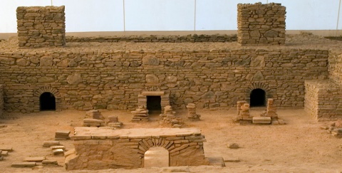
At this side are also the remains of the old Roman Castrum Novae dating back to the 3rd century before Christ. It is one of the biggest and well-preserved Roman camps at the Danube riverside, which does not mean that you can see a lot of it: if the water level is not too high, we can see the remains of a great circular tower, but also the remains of other buildings, which were inside the fortress. But if the water level is high, you will just see a small portion of the fortress. To get to the Roman camp you have to walk upwards on the gravel road and turn right at the crossroad, which is 40m distant from the main road (turning left you get to the camping ground). For the next 350m we follow a curvaceous and really overgrown earthy road, which leads through lush coppice to the Danube riverside and the mouth of the little river Cezava.
60,9km
The tavern Stari Alas (old fisherman) (E) on the left side of the road.
61,6km
The village Dobra. To get to the village centre you have to turn right from the main road. There is a hotel (U) in the village, which is in a bad condition (and which should be renovated in the near future), and two boarding houses with exceptional hospitable atmosphere. The boarding house Stanojevic (E, U) lies at the crossroad to the centre (a journey to their grange can be arranged for guests). The beautiful boarding house Cvetkovic is only 400m away, on the left side of the main road to Donji Milanovac, situated above the river.
There is a small ethno-museum in the motel and in front of it is a spring. You can camp (with permission) in the yard of the local primary school.
65,8km
Rd36 – turning right leads to the detour No.10 (old way to Belgrade, see below). However, our main route is still along the Danube, and we are gradually climbing upwards. (This moderately steep rise grows steeper and steeper as we pass the museum Lepenski Vir, at the height of 225m.)
By remaining on the main road towards the archaeological excavation/museum Lepenski Vir, we ride past the second part of the Djerdap gorge: Gospodjin vir. While advancing towards east, a lonesome and awkwardly shaped protruding from the green mountains on the Romanian side will surely catch our attention – its name is Treskavac (quaky mountain) (people say it got its name because it often gets hit by thunderbolts) and it is right across the museum. So it is useful for our better orientation.
Detour No.10: excursion to the mountains above the Danube, along the old road to Belgrade (18km)
This exceptionally interesting detour is completely covered with asphalt so that we can use it during all kind of weather. The asphalt is of good or very good quality and there is almost no traffic here. The road we are driving on was part of the Danube highway till 1986, which means it was the main link between Golubac and Kladovo and it connected Belgrade with the isolated east of the country. Finally a missing part of the road was built along the river (workers had to built ten tunnels – hence the delay) and the old road, which climbs up the mountain Severni Kučaj was forgotten. It almost disappeared from the roadmaps and now it is there only for the joy of few people who know where it is and are willing to climb it up. It is a bit wider than a soldier belt, wonderfully deserted and adorably beautiful. It can also arouse strong emotions on the Danube road: we will drive through an amazing beech-tree forest, rise to the highest point of the big green wave among the other waves of the great green ocean of Kučaj, and look at the river from a height that gives us wings.
We rise up to 500m above sea level and our ride gets very exhausting. If we drive along the Danube, it is logical that we start at the Point Rd36, so the journey plan is described below. But we strongly recommend riding in the opposite direction – by doing this our journey gets more dynamic (for 6km uphill we get 11km downhill) and the panorama shifts in a beautiful way.
For the sake of orientation, it is enough to stay on the asphalted road – the roads intersecting our road are gravel or earthy roads.
Rd36: 0km (94m over the sea level)
At this crossroad we turn right into a small road that leads through a little village at the beginning. Soon we pass a forest of beech and oak trees. The road rises slowly but constantly.
2,1km (135m over the sea level)
The rise gets more intense.
7,9km (440m over the sea level)
Crossroad with a forest side road; we ride straight ahead. Here we meet the only part of the Detour which is not asphalted on a length of 100-200m. And a short downhill begins, which is a bit longer than 1km.
9,1km (385m over the sea level)
Shortly after we have passed a concrete-bridge, we get to the end of the downhill and to the place where a gravel road of good quality turns left to the top of Sokolovac. We ride straight ahead and remain on the asphalted road; another rise begins.
10,6km (475m over the sea level)
The wide field Kurmatura to our right is the first bigger clearance after we left the forest. On the same side turns a forest side road, leading to the top of Somrda (803km) while our asphalted road turns half-left.
11,3km (510m above sea level)
End of the rise. After a short level part, we ride slowly downhill. There are apple and pear trees next to the road.
11,6km
At this point half to the left begins a gravel road heading for the top of Čoka Njalta (668m above sea level).
12,3km
Another road headed for Čoka Njalta.
15,8km (250m above sea level)
It is time to take a break. A curve bending to the right is decorated with plum trees, beaded with plums. The magnificent baroque-like grassland beneath the bend will catch our attention, and we shall notice the flat blue surface of the Danube. Our sight cannot catch al the magnificence that nature put before us and around us.
At this point the downhill gets steeper (9-10%). We ride among willows, through an area, where land and sky seem to intertwine.
17,6km (100m over the sea level)
To the right turns a gravel road towards the national park Ciganski potok (gypsy rivulet).
17,9km (83m over the sea level)
We enter the main road at the crossroad R106.
69,8km
We ride through the first of 15 tunnels on the way to the museum Lepenski vir. Most of the tunnels are short (up to 100m), but three of them are longer than 200m and this is one of them. Although the traffic is moderate and there are sidewalks in the tunnel, you have to switch on the lights. The pointer at the beginning of the tunnel says “T21”. (The numbering of the tunnels begins from Kladovo towards Golubac, meaning that there are 21 tunnels altogether on the Danube-highway.)
Next tunnel (T20), following the first one, is over 200m long.
72,8km
Entry to tunnel T14, which is the longest one on the road to the museum. It is 256m long.
77,7km
R105 – after the tunnel T10 we reach a point, where begins an asphalted road to the left towards the museum. We shall move on along this road.
77,9km
After a short and steep downhill we arrive at the parking lot of the museum. After the entry there is a beautiful field with some old houses in traditional style (mini-ethno-village), occupied by museum guides and watchmen. There is a spring at the entry.
The field is a wonderful place to camp, one of the most beautiful along the Serbian part of the Danube. However, it is not an official camping ground. But we are likely to get the permission to pitch two or three tents. On the right side, beneath the field is another place fit for camping, which some fishermen use. There is also a small facility with running water. You can reach this place while riding down the short pathway to the right from the parking lot.
Lepenski Vir
The culture of Lepenski Vir lasted from 8000 till 4500 A.D. Archaeological researches carried out from 1965 to 1968 discovered that the existence of the three historical stratums, contained in the remains of eight villages. The remains of houses, artefacts, tools and sculptures prove that the village inhabitants possessed a high level of social order, spiritual and material culture, in a very long period of time from the first colony of hunters and food collectors up to the farm workers and stock farmers later in the Neolithic era. Apart from Lepenski Vir, similar colonies also existed in the nearby villages of Vlasac, Padina and Hajducka vodenica in Serbia, and Sheila Cladovei on the Romanian riverside.
Beneath the older Neolithic colonies (the famous Starcevac group), unknown memorials of prehistoric culture and art were discovered: a colony with impressive architectonical remains and exceptional sculptures of stone. There were more than 100 well-preserved house-foundations with a surface of 5 to 30 sqm, and fireplaces, as well as more than 50 sculptures made of big quartz-stones, which were an important part of the complex scheme of fireplaces and their surrounding. Houses had floors of solid material covered with glaze. The sculptures are genuine pieces of art, which did not exist in the Proton Eolithic and Neolithic cultures. They are the oldest artworks in Serbia, dating from 5000 A.D.
When the Đerdap hydroelectric plant was built, it provoked the rise of the water level, because of which the whole city became a mountain valley and was transferred to the superior point. Next to it is the museum with numerous pieces, which were found at the diggings.
We continue our journey by riding over the parking lot, eastwards (down the river), so as to avoid riding back uphill. At the opposite side of the parking lot, we should notice a small asphalted road in the cliff. This remarkable road goes along the Danube and offers an amazing view. About 700m after the parking lot is a place with an especially nice view, where the sound of cameras making photos gets mixed up with the singing of birds.
79,3km
We ride under a highway bridge, and reach a charming little canyon of the Boljetinian River. We ride past bacon-like cliffs, divided into hundreds of thin layers. Some layers are almost vertical due to the force of tectonic movement. Depending on water level we will ride for about 10m through shallow water, which will be a piece of cake to us – to spice up our experience of the place. This canyon belongs to the national park and it is not only geomorphologically important but it is also a place where the Mesolithic fossil fauna is found in abundance: we will have the pleasure to ride through this beautiful place with prehistorical dust beneath our wheels..
79,5km
R106 – at the end of the canyon is a crossroad on a little concrete-bridge, with road signs on it. The right branch of the crossroad is an end of the Detour, mentioned above. We ride straight ahead, towards Boljetin and the exit to the main road.
79.8km
R107 (95m above sea level) – a crossroad with a pointer with the directions to Ciganski Potok and Boljetin. Our journey continues by turning half-left and steep up a steep hill.
80,2km
R108 (120m above sea level) – gateway to the highway. We make a right turn. The rise is not as steep as the on the access route, but we will sweat a little bit.
82,5km
Boljetin Mountain – end of the uphill, at 224m above sea level of. From this point we can see the Danube bathing and playing with its catfishes and fishermen. Here begins a beautiful downhill to the river, which is 3km long: it has three lanes of great quality, less traffic, the blue wideness of the river is ahead of us – here we have everything we need for a genuine Rock`n`Road. We enter the chest of the wide bay beneath the cape named Greben, another place where the Danube is more than:2km wide.
90,3km
R109 – a right turn leads to Majdanpek.
We recommend to interrupt the journey to Milanovac and follow the uphill road to the gallery “Human, wood, water” (E, U), which is one of the most beautiful and most interesting places along the Serbian Danube riverside. About 1,7km after R109 and at 160m above sea level we reach a wooden fence and marker, inviting us to the fruit orchard, where more than 10 sculptures of Mr Zivorad Stefanovic are displayed. They are all made of wood.
The artist, who lives here with his family, offers local tourism, so we can enjoy the exquisite ecological cuisine, drink mead, which is made by an old recipe, and chat with local people, which successfully escaped the city life. You can also spend the night here. Bonus: if we leave a good impression, we will get a dried and coated mushroom Ling-Ve-Chi (fairy silk) as a gift.
3,3km
The restaurant Lepena (E) on the left side.
94,6km
R110 – a triangle-shaped crossroad at the gas station at the entry to Donji Milanovac. The main road bends to the right towards the hotel Lepenski Vir (E, U) and Kladovo. We take a left turn towards the centre and the river. (It would take us just the same to reach the exit of Donji Milanovac if we take this road instead of the main road) Directly after the crossroad is the boarding house KMZ (E, U) on our left.
94,8km
On our left is the town-hall with the head office of theNational park Đerdap and after 50m is a bus station and the centre of Donji Milanovac. Here begins a nice park, which goes on to the riverside of the Danube, the pier and the boardwalk, where the atmosphere as if we are at the seaside.
The travelling city
Donji Milanovac is the city with the most sun-hours in Serbia and a place, where the Danube is very wide, about 2km. The city dates back to 1690, when Serbian population, fleeing from the Turks, inhabited the island Poreč, about 10km upriver from where we are now. During the first two centuries of its existence the survival of the population depended on the Danube: besides fishing and trade, people lived from navigating ships downriver and hauling them upriver. Because of numerous floods and poor transport links, in 1832 the Serbian monarch Milos Obrenovic, ordered that the city be shifted 6km upriver. The new city, the first one in Serbia built according to the urban plan, was named after the son of the ruler, Milan Obrenovic.
In 1970 due to the built of hydroelectric plant Đerdap and the formation of a storage lake, the city was moved once again, this time some 4km upriver. Today the city occupies the place of the former Latin cestrum of Taliat which symbolically gives people hope that there would be no more migration – but if the history of Donji Milanovac should repeat, there is the possibility that this city will once, with their inhabitants, reach the mouth of the Danube.
However, we will remember Donji Milanovac for its tranquil doze: this town and its citizens seem to slumber waiting for better days. If the water level falls for more than 5m, the remains of the former Milanovac appear from the water. Then the major street and the remains of the church, the mall, the city hall and edifices wishfully pant for air.
1. Regarding waypoint you are interested in always check in your GPS the field with its additional description: there you can find full name of the waypoint as well as various additional information.
2. Waypoint system is designed to show direction down the river; for example waypoint “asphalt start” means the asphalt starts at that point when you have in mind defined direction – if you travel up the river stream this would then be the place where asphalt ends.
3. Situation at the field continuously changes, therefore GPS data here given can be changed or updated – that is why we recommend that you download the data from the web site right before the planned journey.
4. If you find some inaccuracies or you wish to add some new GPS data you find important, please inform us using this address.
Explanations for abbreviations used in waypoint denotations:
• Number without any letters: number of the crossroad at the main route (corresponding to the number on the map and number on the sign-post at the field)
• Alt + number: number of the crossroad at alternative route (corresponding to the number on the map and number of the sign-post at the field)
• D + number: number of the crossroad at detour
• S: turning point
• Vo: water (spring, drink-fountain etc.)
• asf st: beginning of the asphalt road
• asf end: end of the asphalt road
• cycl: bicycle parts selling store and/or bicycle service and/or bicycle center
• Muz: museum
• Ht: hotel
• Mot: motel
• P: pension
• car: čarda (fish restaurant)
• kaf: tavern
• T: tunnel
• Names of inhabited posts are written with capital letters
DANUBE.TRAVEL has no control over the website content generated by users and/or visitors, neither such content represents a statement, opinion, recommendation or rating by DANUBE.TRAVEL. For further information please refer to DANUBE.TRAVEL – General Website Terms and Conditions of Use.
Places near this location
Where to stay
What to do
Danube experience